Artificialization with CLC+
French NSI TEAM: Clément Guillo, Raya Berova, Damien Babet
10 mars 2025
1️ ONE number
One number

One number
+8%
One number
+8%
The growth or urbanized area in East Sussex, United Kingdom, between 2018 and 2024
One number
2️⃣ One RELEVANT number !
Land Use Change
We focus on artificialization, defined here as a rise in imperviousness : “the disappearance of natural spaces under concrete or bitumen”
Imperviousness negatively affects biodiversity, carbon storage and sequestration, soil hydrological properties, ecosystem services and nature conservation.
The European Commission’s roadmap to a resource efficient Europe introduced a ‘no net land take by 2050’ initiative
CLC+ Backbone
Land cover and land use: an important topic with a lot of work done.
The most recent and accurate datasets are the Corine Land Cover Plus (CLC+) Backbone
Everything we did is built on the CLC+ Backbone : CLMS Data Viewer
3️⃣ The INNOVATION behind the relevant number
Segformer model
We trained a segformer model on Sentinel-2, - mosaic images of 250*250 pixels (resolution = 10m) - all 12 bands + NDVI and NDWI
Xie, Enze, et al. “SegFormer: Simple and efficient design for semantic segmentation with transformers.” Advances in neural information processing systems 34 (2021): 12077-12090.
Architecture
4️⃣ The REPLICABILITY of the innovation behind the relevant number
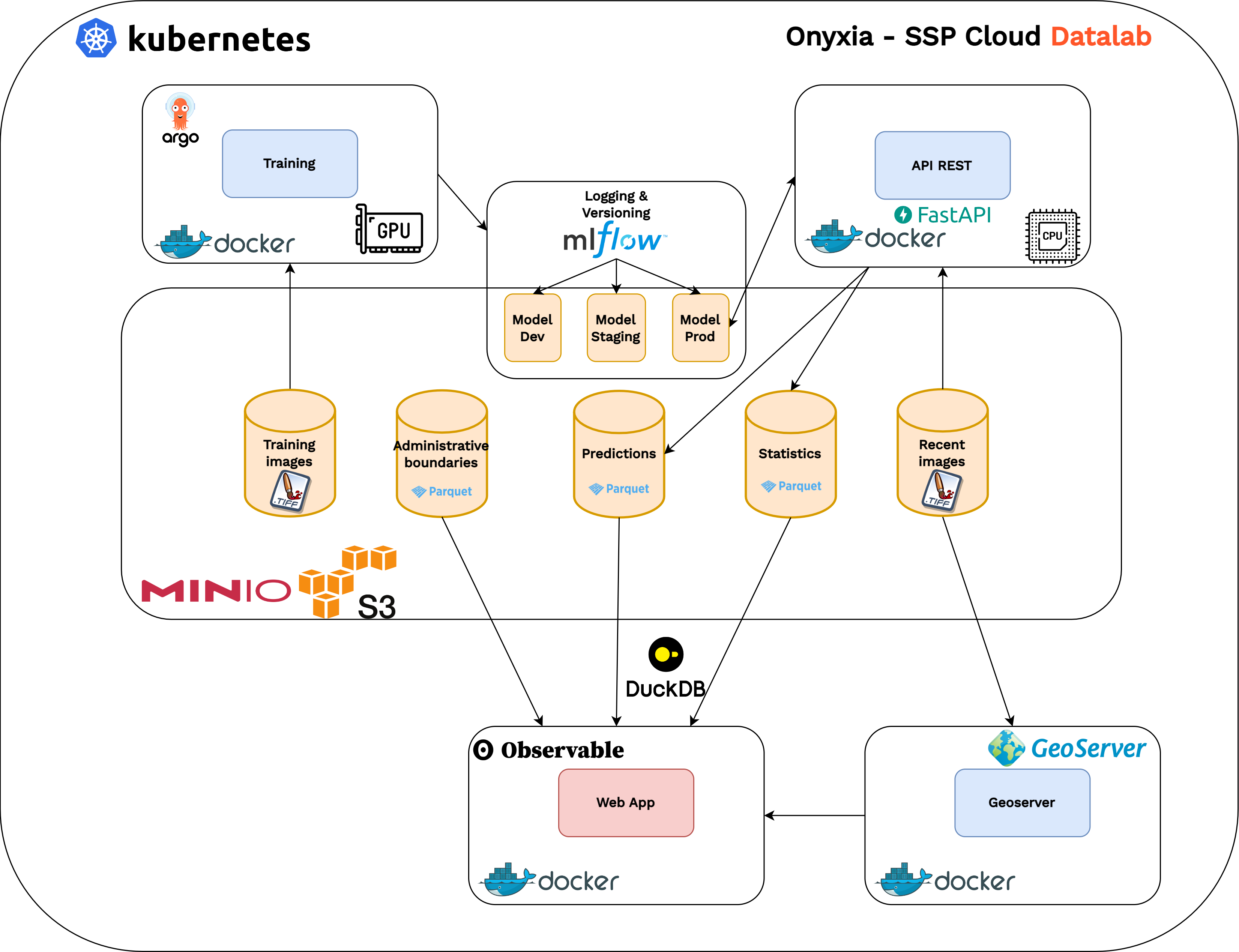
You CAN do this at home
- Use the webapp
- Access our layers on geoserver
- Predict on new Sentinel-2 images with the API
- Download the model on Hugging Face to retrain and play
- Use our complete stack: it is containerized
5️⃣ One RIGOROUS number ?
Are the results reliable ?
Correctly estimating land cover area is a hard problem
Sannier, Christophe, et al. “Harmonized Pan-European Time Series for Monitoring Soil Sealing.” Land 13.7 (2024): 1087. Link
Olofsson, Pontus, et al. “Good practices for estimating area and assessing accuracy of land change.” Remote sensing of Environment 148 (2014): 42-57. Link (.pdf)
Model performance
We assess the model predictive performance relative to the CLC+ reference
We use cross-entropy loss with or without weights
and track intersection over union (IOU) for the “1: sealed” CLC+ category
Test sample metrics: IOU “1/ sealed” category: 0.46 IOU all categories: 0.63
Next step is confronting with ground truth data: LUCAS survey points
A quite good predictor is not enough
- A predictor can be good but biased. Cross-entropy is biased when we use weights
- Unbiased errors can translate to bias when measuring evolutions
- Fundamentally, results depend on resolution, due to the fractal nature of artificialisation
These problems might exist already at a smaller scale for CLC+
An exploration tool
+8% is not a reliable number
But a fast trained prediction model is a good tool to explore !
Our Background
Satellite tracking of settlements changes in French oversea territories, for a better census With a dashboard!
Other LU/C and imperviousness Sources
Urban Atlas ➡ Only for cities, last available data : 2018
European Environment Agency ➡ last available data : 2018. Bias correction for long term series
High Resolution Layer Imperviousness ➡ last available data : 2018
References
Beyond the Modifiable Areal Unit Problem, François Sémécurbe
Sannier, Christophe, et al. “Harmonized Pan-European Time Series for Monitoring Soil Sealing.” Land 13.7 (2024): 1087. Link
Olofsson, Pontus, et al. “Good practices for estimating area and assessing accuracy of land change.” Remote sensing of Environment 148 (2014): 42-57. Link (.pdf)
Xie, Enze, et al. “SegFormer: Simple and efficient design for semantic segmentation with transformers.” Advances in neural information processing systems 34 (2021): 12077-12090.
References 2
Gergely Maucha (Lechner Ltd.), Éva Kerékgyártó (Lechner Ltd.), Viktória Turos (Lechner Ltd.), Christophe Sannier (GAF), Jaroslav Dufek (GISAT), Tomas Soukup (GISAT), Eva Ivits (EEA), Analysis of usability of Imperviousness and CLC+ Backbone data for mapping sealed areas, ETC DI Report 2024/3, 13 Jun 2024 Link
Pelletier, Charlotte, Geoffrey I. Webb, and François Petitjean. “Temporal convolutional neural network for the classification of satellite image time series.” Remote Sensing 11.5 (2019): 523 Link Repo
Product user manual – CLCplus Backbone 2021 Publication date: 12.06.2024 Version: 1.2 Link